盛港:泥泞乡道的涅槃
文图 · 李国樑

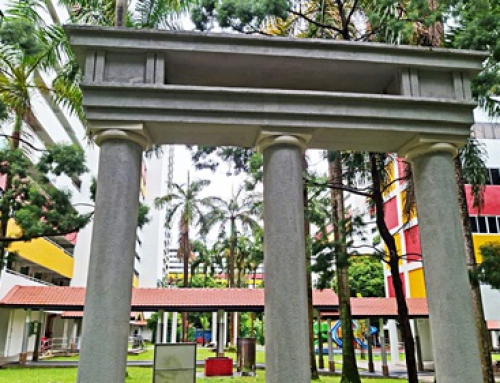
轻轨下展现艺术创意的盛港雕塑公园,通过海洋生物和捕鱼人家的雕塑展现渔村历史
新加坡东北部的盛港(Sengkang)以后港(Hougang)、榜鹅(Punggol)、实里达(Seletar)、白沙(Pasir Ris)为界,面积和乌敏岛相似。1997年首批盛港组屋区在实龙岗河谷完工,如今25万人居住在6万多个组屋单位的成熟市镇。
与其他人口稠密的市镇相比,盛港不像兀兰有地铁汤申线和南北线;也不像淡滨尼有东西线、滨海市区线和正在兴建中的跨岛线。东北线来到盛港,由轻轨为居民续航,与榜鹅和武吉班让(Bukit Panjang)采纳同一个交通模式。
拗口的地名
盛港不像多数组屋区以第几道第几街命名,地名甚至有些拗口。盛港的7个分区:河谷(Rivervale)、康埔桦(Compassvale)、安谷(Anchorvale)、芬薇(Fernvale)、盛港镇中心、盛港西,以及罗弄哈鲁士北(Lorong Halus North),您记得多少呢?在没有定位导航的年代,连在公路奔驰多年的德士司机都无所适从,感叹自己去了“荷兰”。
笔者花了好些心思,终于弄明白实龙岗河与榜鹅河之间的“两河流域”,是顺着河(river)、指南针(compass)和船锚(anchor)从东到西排列的,榜鹅河以西则属于链束植物(fern)茂盛的湿地。规划师以河流、渔船器具、水生丛林,还有一座以海洋为主题的雕塑公园来“还原”盛港的原生态,巧思不在话下。
盛港、港脚与半港
从前的两河流域有港脚、半港和榜鹅,榜鹅已“独立”成为仍在茁长中的新镇。至于盛港这么“兴盛的港口”竟然闻所未闻,那是怎么回事呢?
让我们从港脚谈起。港脚指的是实龙岗七条半石的“河口”,也就是昔日实龙岗路上段的尽头。上世纪80年代初,这里仍然是实龙岗村和渔港中心,上百艘渔船为本地提供新鲜海产。居民在更遥远的实龙岗河支流双溪登雅(Sungei Tengah)安家,因此出现河畔的甘榜双溪登雅。
甘榜双溪登雅地处“内陆”,因此俗称半港,有条名为罗弄盛港(Lorong Sengkang)的乡道,今日盛港就是以此乡间小路命名的。甘榜双溪登雅这个昔日盛港中心,就是今天的康埔桦,大家不妨想象康埔桦巷(Compassvale Lane)的盛港中学门前小河淌水,学生放学后嬉水取乐的光景。

1953年盛港地图,可见“两河流域”之间的半港和占地广阔的万国橡胶园和烟草园
康埔桦 从前半港的中心
甘榜双溪登雅位于从前榜鹅路九英里,两河流域的中心地带当然少不了学校、联络所和宗教场所,距离甘榜半公里曾经出现过明德和树德两所小学。
明德学校(1932-1985)由天主教会创办,关闭时安排学生转读圣婴小学,原址兴建圣若瑟修院学校(CHIJ St. Joseph’s Convent)。榜鹅的树德轻轨站(Soo Teck)以树德学校命名,盛港第249座组屋一带就是学校原址。这是一所二战后民办的乡村小学,校长黄华光的后人黄惠麟描述:“也许你有所不知,每天下午班放学后,校长的六七个孩子就一人一间擦黑板、扫地、倒垃圾、关窗关门,十年如一日。另一些趣事:学校没有音乐教室,只有一台风乐机。上音乐课的班级便会上演孔明借灯,将风乐机扛来扛去。碰上儿童节、国庆日,学校几间教室就会打通变成一间‘大礼堂’,蛮有气氛的。学校校旗是校长女儿设计,校长夫人缝的。校长外号‘阿牛’,牛脾气来时打你屁股开花。”学识渊博的校长身兼多职,也是村长、地区姓氏公会委员和公民咨询委员会主席,时任总理李光耀下乡访问,他还是欢迎会主席呢!
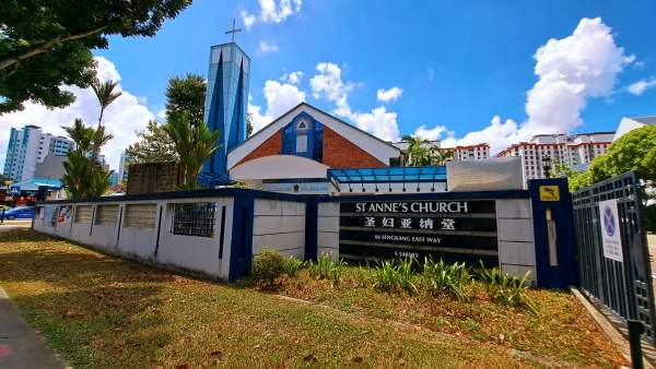
1963年落成的圣妇亚纳堂是唯一的时代见证者
1963年落成的圣妇亚纳堂(St. Anne’s Church)是盛港唯一的时代见证者。教堂开放十余年后,附近住户接到搬迁通知。神父以为山穷水尽,甚至考虑将教堂大门永远关闭。哪知柳暗花明又一村,高楼居民带来人气,也为教堂带来生机。
安谷Anchorvale
从前的安谷是辽阔的万国橡胶园和烟草园(Singapore United Plantation),如今多座组屋、学校和医院坐落在昔日种植场。盛港综合医院与盛港社区医院在同一院址,所采纳的是上世纪90年代末启用的樟宜综合医院模式。当时四美的樟宜综合医院取代樟宜医院和大巴窑医院,主要提供全面的急诊、住院和门诊临床专科服务。圣安德烈社区医院于90年代初已提供复健护理,2000年代中期搬到樟宜综合医院院区,患者从综合医院“出院”后由社区医院接手,帮助他们尽快重返家园。
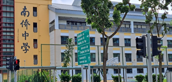
南侨中学是安谷唯一的中学
南侨中学是安谷唯一的中学。南侨于金炎路创校,90年代因市区一带人口迁徙,收生率持续下滑而饱受卧薪尝胆的滋味。千禧年初教育部政策改变,将辅助学校管理权和土地拥有权脱钩。福建会馆接受政府赔偿,南侨落户盛港,成为第11所特选中学。
目前安谷正在如火如荼地兴建另一所中学——欧南中学,预计2026年从现在的约克山搬迁到盛港,持续其教育使命。欧南中学的处境跟昔日南侨相似,面对周遭人口减少的困境,由于它是一所政府中学,寻找新地方、保留校名等都较易处理。
芬薇的盛港河畔公园
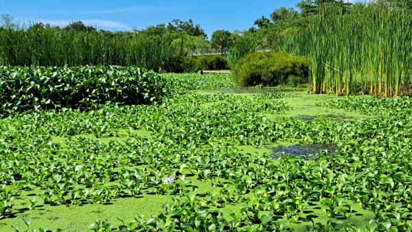
盛港河滨公园是“大自然中的城市”绿洲
芬薇是仍在扩建中的分区,为芬薇保留昔日湿地生态的当数榜鹅河畔的盛港河滨公园(Sengkang Riverside Park),让相对年轻的组屋区出现“大自然中的城市”绿洲。公园的人造漂浮湿地面积约半个足球场,通过水生植物自然收集和过滤雨水,净化蓄水池的水质和促进生态平衡。它也是野生动物的栖息地,吸引紫苍鹭、鸬鹚和小燕鸥等红树林飞禽。
从前新加坡超过九成的土地是密林,人口增加后变成“自然里的农村”。密林变民居的过程中,无可避免地造成自然生态的流失。新加坡独立的首50年,创建了以公园、花园和开放空间为基础的“花园城市”,如今的理念是,将城市回归自然,重建消失的绿地来减轻城市化的负面影响。
目前本岛已有50多条水道改头换面,能够更有效地排水。回顾新加坡近代史,低洼地区常发生水灾,上世纪50至70年代的几次大水灾,造成严重破坏以及生命和财产损失。二战后,公共工程部进行改善排水系统工程,例如拓宽和加深排水网络、加高低洼地区的道路,以及在河流和水库修建排水沟和防潮闸门。
新加坡独立后,由于开发土地兴建住宅、工业区而去森林化,导致水灾事件随之加剧。各政府相关部门于1970年代中期联合改造排水系统,总体规划河道、湿地、蓄水池及打造绿色设施。在舒缓淹水、收集雨水的同时,也为居民提供了开门就可休闲的好去处。
新加坡自治之前,林德委员会报告书提出新加坡无法独立的原因之一,就是食物与水来自马来亚联邦,无法自供自足。我们曾经过度依赖邻国供水,因此,新加坡努力不懈地解决水资源和基本生存的挑战。如今公众可以更近距离亲近洁净水,“水城”将是我们留给子孙后代的宝贵资产。
河谷的宗教场所
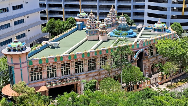
河谷的阿鲁密古兴都庙是一座由三间兴都庙组成的“联合宫”
河谷的阿鲁密古兴都庙(Arulmigu Velmurugan Gnanamuneeswarar Temple)是一座由三间兴都庙组成的“联合宫”。第一间是二战后建立的克里斯南兴都庙(Sri Krishna Bhagawan Durga Parameswari Temple),主要信众是居住在实里达和惹兰加由(Jalan Kayu)的印度移民。小庙饲养奶牛,多年来为附近居民供应新鲜的牛奶粥(paal payasam)。第二间马里安曼兴都庙(Sri Mariamman Muneswarar Temple)因信徒体验到奇迹而蒙上神秘色彩。第三间阿鲁密古兴都庙(Arulmigu Velmurugan Temple)原址在石叻路(Silat Road),为居住在火车轨道旁的马来亚铁道局员工提供心灵寄托。
这三座寺庙的负责人都希望建造永久性建筑来供奉神灵,最终在盛港达成所愿。大堂采用透光玻璃和透视圆穹顶,与现代泰米尔纳德邦(Tamil Nadu)的庙宇格局相似。兴都庙每12年举行一次祝圣仪式,隔壁华人的崇义庙开放场地供邻居招待宾客,还有舞狮和马来传统鼓表演助兴。
诞生-600x355.jpg)
半港天后宫于百年前在甘榜双溪登雅(半港)诞生
说来凑巧,崇义庙也是三合一的联合宫,其中半港天后宫于百年前在甘榜双溪登雅诞生。靠海为生的人士源自先民习俗,半港居民多数捕鱼为生,因此供奉妈祖祈望得到庇护。上世纪80年代,半港天后宫搬到乌敏岛,千禧年之后搬回盛港,为从前的半港留下故土足迹。
面对故土,多少会带着月是故乡明的赤子情怀。半港的年代,两河流域几乎全是华人,如今盛港的华族居民仍然偏多,马来居民少过百分之十。崭新的慈爱回教堂(Al-Mawaddah Mosque)为盛港与万国地区的年轻回教家庭兴建,名字取义自《可兰经》“祂从你们中间创造了配偶,以便你们安居,祂把慈爱(Al-Mawaddah)放在你们心间。”
罗弄哈鲁士北
罗弄哈鲁士北有条连接巴西立和榜鹅的绿色走廊,展现别致的热带草原风情。这片人造湿地面积约18个足球场,种植芦苇、伞纸莎草、香根草来净化水源。
半个世纪前,罗弄哈鲁士沼泽地是由三个甘榜组成的马来村庄,原居民多数搬迁至淡滨尼新镇。这里也是粪便处理场、污水处理场、垃圾收集场,以及从苏门答腊运来的火炭卸货地点。
上世纪70年代国会开会时,就新加坡花园城市还使用粪桶一事,环境部被轰得体无完肤。到了1987年,设在罗弄哈鲁士的最后一个粪便处理场和污水处理场停止运作,粪桶的百年气味成为没人愿意回想的往事。垃圾收集场则于1999年关闭。从那时起,全国焚烧后的垃圾灰烬、不可焚化的废料都集中在大士海运转运站,再由平底船运往实马高垃圾埋置场。“垃圾岛”使用寿命预计会在十年内结束。如何把垃圾更有效地转换成能源或建筑材料,是目前关注的课题。

罗弄哈鲁士北红桥两岸,分别朝迎旭日升,暮送夕阳下
罗弄哈鲁士北的地标就是紧邻湿地的红桥。红桥外形像座火车钢桥,桥的两岸一头朝迎旭日升,另一头暮送夕阳下。人在这样的氛围中体味到时光荏苒:盛港,那泥泞乡道,早已涅槃重生。
注释:
[1]Arulmigu Velmurugan Gnanamuneeswarar Temple, https://www.avgmt.com/ accessed 11 April 2024.
[2]Khoo Teck Chye et al., Urban Systems Studies The Active, Beautiful, Clean Waters Programme: Water as an Environmental Asset, Centre for Liveable Cities (CLC) Singapore 2017.
[3]Masjid Al-Mawaddah, https://en.wikipedia.org/wiki/Masjid_Al-Mawaddah accessed 28 November 2023.
[4]Our History of Healthcare, https://www.roots.gov.sg/stories-landing/stories/history-of-he-alth-care-sg accessed 10 April 2024.
[5]The Parish of St Anne’s Church, https://stanne.catholic.sg/about-stanneschurch/accessed 10 April 2024.
[6]Vernon Cornelius & Aisyah Hamid, Sengkang, SINGAPORE INFOPEDIA https://www.nlb.gov.sg/main/article-detail?cmsuuid=d43d5dda-40eb-4d49-a913-0e8a5fb8a5b1 accessed 28 November 2023.
[7]黄惠麟,公立树德小学,
https://www.facebook.com/groups/265763383605892/permalink/2445913458924196 accessed 29 November 2023.
[8]《联合早报》
(作者为英国皇家造船师学会会员、自由文史工作者)
Sengkang: Rebirth from a muddy country road
Sengkang is located at the northeast of Singapore and is similar in size to Pulau Ubin. The first batch of Sengkang HDB flats was completed in Rivervale in 1997. Today, 250,000 residents live in this “water town”.
Sengkang is divided into seven subzones including Rivervale, Compassvale, Anchovale, Fernvale, Sengkang, Sengkang West and Lorong Halus North. In the days when GPS was still unavailable, even taxi drivers who were on the road all year round were at a loss and lamented that they had gone to “Holland”.
Well, the “Valley” between Serangoon River and Punggol River is split into river, compass and anchor districts from east to west, while west of Punggol River is an aquatic “wetland” covered with “ferns”.
Before development, Kangkar, Half-Kangkar and Punggol were located along the valley between the two rivers. Punggol has become “independent” and is still growing as a new town. Kangkar refers to the “estuary” of the seven and a half miles of Serangoon.
In the early 1980s, Kangkar was still a bustling village and fishing port, with hundreds of fishing boats providing fresh catches locally. Residents also built houses further away on Sungei Tengah, a tributary of the Serangoon River, forming Kampung Sungei Tengah.
Kampung Sungei Tengah was popularly known as Half-Kangkar where the muddy Lorong Sengkang ran across the village. Indeed, Sengkang town is named after this small country lane. Meng Teck School and Soo Teck School were once located nearby. The Catholic Church founded Meng Teck School (1932-1985). Today’s CHIJ St. Joseph’s Convent was built on the same site.
Punggol’s Soo Teck LRT station is named after the privately-run Soo Teck School, currently where the HDB block 249 is located. Due to a limited budget, the children of the village school principal had to help to clean up the classrooms after school. The school flag was designed by the principal’s daughter and sewn by the principal’s wife. The principal, a man of profound learning, was also the village chief and the chairman of the welcome committee for the visit by the late Prime Minister Lee Kuan Yew then.
St. Anne’s Church, completed in 1963, is the only witness to the eras here. About a decade after the church opened for prayers, the residents nearby received the notification to relocate. The late Father Berthold had then considered to close the church but eventually the blue print of the new towns indicated that the church’s location is right in the centre.
The former rubber and tobacco plantations of Anchorvale which were once under the Singapore United Plantation, are now home to HDB flats, schools and hospitals. At present, Nan Chiau High School is the only secondary school in Anchorvale. The school, founded on Kim Yam Road, nearly shut its doors in the 1990s as the enrolment rate continuously declined. At the beginning of the new millennium, the Ministry of Education changed its policy to decouple the management of aided schools from land ownership. The Hokkien Huay Kuan accepted the government’s compensation. Nan Chiau High School started to settle down in Sengkang and was designated as the 11th Special Assistance Plan (SAP) school.
Another secondary school, Outram Secondary School, is expected to move to Anchorvale in 2026. The situation of Outram Secondary School is similar as that of Nan Chiau High School, facing the dilemma of population decline in the York Hill area. However, relocation is much easier since it is a government school.
The Arulmigu Velmurugan Gnanamuneeswarar Temple in Rivervale combines three Hindu temples into one. While this practice has become the norm for many Chinese rural temples, it is less common in others.
The Sengkang Riverside Park on the Punggol Riverbank preserves Fernvale’s wetland ecology. It provides a relatively young estate with a “City in Nature” oasis.


-500x383.jpg)
-500x383.jpg)
